Showing 5 items matching anniversary trails
-
 Surrey Hills Historical Society Collection
book, Wattle Park Draft Management Plan, Sept 1991
... Anniversary trails... Gardiner's Creek Anniversary trails vegetation Wattle Park Chalet ...This draft management plan has been developed after consultation with park users, and specific interest groups. It takes into account the findings of market research and community liaison.An A4 sized bookletOn top RH corner of cover: "JF Hall/own"wattle park (box hill, vic) - planning, parks - victoria- box hill- management, gardiner's creek, anniversary trails, vegetation, wattle park chalet, wattle park golf course, land use, melbourne water, riversdale golf course, national trust, riversdale road, surrey hills -
 Kew Historical Society Inc
Photograph - High Street, Kew, 1960-65
... to a walkway [now the Anniversary Trail], which once provided access... there is an entrance to a walkway [now the Anniversary Trail], which once ...The borders of the main components of Kew and Kew East have not always conformed to current boundaries. In the past this photograph has been labelled as East Kew, whereas for most of the twentieth century the site has been within Kew's borders. The purpose of the photograph is unrecorded yet it has value in that it shows those businesses who occupied this site in Kew during the early 1960s.This small photograph is significant as it shows the location of and building used by WD Vaughan, former Mayor of Kew who was a successful newspaper proprietor in Melbourne.Small polaroid colour positive of High Street in Kew, probably in the 1960s. From left we can see the brick viaduct covering the tracks of what was once the Outer Circle Railway. Behind this brick wall, Dunnings Timber Yard was situated. At the end of the walls of the viaduct there is an entrance to a walkway [now the Anniversary Trail], which once provided access to Windsor Avenue, and also to the East Kew Station (now demolished and part of the Outer Circle Railway Reserve). On the other side of this walkway is a cream brick building (demolished) occupied at this time by WD Vaughan Pty Ltd, printer and publisher of the Kew Advertiser (newspaper). Stretching behind the brick facade is an extensive building that must have housed the printing works. Beside Vaughan's, there is a large building (demolished) housing at that time an estate agent named AJ Kennedy. This area is now separated by kerbing.High St East Kew / Corner of Harp Rd. / Looking South -
 Eltham District Historical Society Inc
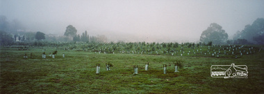
Photograph, Barak Bushlands Reserve, Eltham, March 2003, 2003
This area is urban and wetlands west of the Eltham gateway approach near the bridge over Diamond Creek and forms part of a walking trail. On 15 August 2004, the Shire of Nillumbik officially named the area "Barak Bushlands" as part of its commitment to Aboriginal reconciliation. The naming day memorialised the one hundred and first anniversary of the death of the last full-blood Yarra Aboriginal leader, William Barak. Source: Aboriginal reconcilation events in Nillumbik, Ken Eckersall, 2006.Digital scan from borrowed photobarak bushlands reserve, eltham, walking trail -
 Eltham District Historical Society Inc
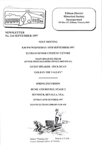
Newsletter, No. 116 September 1997
Contents: • Next meeting, guest speaker; Jock Ryan: Gold in the Valley • 846-848 Main Road Eltham • Society 30th Anniversary • Council Matters • Visitors from Eltham • September Meeting • Spring Excursion • The Heidelberg School Artists Trail The Shire of Eltham Historical Society was formed in October 1967. The first newsletter of the Society was issued May 1978 and has been published continuously ever since on a bi-monthly basis. With the cessation of the Shire of Eltham in late 1994, the Society's name was revised to Eltham District Historical Society and this name first appeared with issue No. 103, July 1995. The collection of the Society's newsletters provides a valuable resource on the history of the Society's activities, office bearers and committee members, guest speakers and subjects of historical interest pertinent to the former Shire of Eltham and the Eltham District.A4 photocopied newsletter distributed to membersnewsletter, eltham district historical society, shire of eltham historical society -
 Port Melbourne Historical & Preservation Society
Document - Presentation kit, 150th Anniversary M&HB Railway, Victorian Department of Infrastructure, Aug 2004
Kit presented to attendees at celebratory breakfast for 150th Anniversary of the M&HB railway, in pink & copper. .02: Invitation to the breakfast .03: Badge '150 Victoria' gold coloured .04: Set of 4 railway postcards ('maximum cards') .05: Fridge magnet from PROV (grey & black) .06: Card designating table 16, where 9 PMH&PS members sat .07: "Sandridge Railway Trail" - DL tour guide .08: "Making Tracks" - DL brochure about RHSV exhibition .09: "Stampspotting" - DL exhibition brochure (Aust Post) .10: "Rebuilding Regional Rail" - A4 brochure re new developments in Vic Rail .11: "Celebrating the 150th Anniversary of Victorin Railways" - double-sided A4 fact sheet, copper & pink .12: Seven related media releases from various auhorities .13 RHSV form for telling railway stories. (May be missing August 2013)transport - railways, piers and wharves - station pier, piers and wharves - railway pier, peter batchelor, department of infrastructure, melbourne & hobsons bay railway